Manipur: Is Regarded As The Switzerland of India
Manipur has been regarded as the Switzerland of India as described by Lord Irwin. Boasts of an exotic landscape with gently undulating hills which sorrounded the valley all over which seems like clouds covering the entire manipur, emerald green valleys, blue lakes and dense forests. Culture which makes manipur more exotic. It is situated in the Purbanchal area which is the end of Himalaya.
It is the sheer tranquility enveloping it, interrupted only by a soft breeze that sets it apart from the other northeastern states, and makes it the ideal getaway. Its weather condition is moderate almost all through the year which make people more comfortable in any season. Manipur, literally meaning the land of jewel, is a paradise on earth when Mother Nature has been extra generous in her beauty. And from the very inception, this princely state of Manipur has always been a shinning outpost of the country in the sparse of the eastern Himalayas.
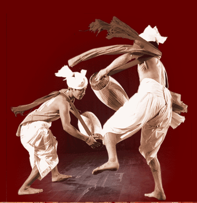
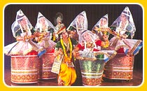
Know about Manipuri dance! just click for all information.
 Literally manipur geographical area is one of the best in north eastern India. Manipur is a part of India both from the point of view of geography and culture.
It never lost its basic link with the mainstream of the Indian culture.
The culture of Manipur has been a part of Indian culture.
Literally manipur geographical area is one of the best in north eastern India. Manipur is a part of India both from the point of view of geography and culture.
It never lost its basic link with the mainstream of the Indian culture.
The culture of Manipur has been a part of Indian culture.
It accepted aspects of Indian culture and transmitted them to Burma, China and other lands of East Asia. On political grounds Manipur can hardly be separated from India. We find the invaders from Cachar, Tripura, etc., during the successive periods of it's history. The religious movement of Manipur in the 18th century conveys the spirit of universality and strengthen the bounds of unity. It asserts that Manipur is a part of Bharatavarsa.
Manipur
Manipur pronunciation (help·info) (Bengali: মণিপুর, Hindi: मणिपुर) is a state in northeastern India making its capital in the city of Imphal. Manipur is bounded by the Indian states of Nagaland in the north, Mizoram in the south and Assam in the west; it also borders the country of Myanmar to the east.
The Meiteis, who live primarily in the state's valley region, is one of the primary ethnic groups. Their language, Meitei (also known as Meiteilon or Manipuri), is also the lingua franca in the state. Manipur is formed by different communities. The meiteis has maximum population and the next is Manipuri Muslim (known as Pangal).It was recognized as one of India's national languages in 1992.
Manipur is considered a sensitive border state. Foreigners entering Manipur (including foreign citizens born in Manipur) must possess a Restricted Area Permit which can be obtained from the Foreigners Regional Registration Office in the "metros" (Delhi, Mumbai, Kolkata) or certain other state government offices. Permits are valid for only 10 days, and visitors must travel only on tours arranged by authorised travel agents, in groups of four. Furthermore, they may come to Imphal only by air and will not be permitted to travel outside the capital.
History
Manipur and Assam became involved in the disputes between Thailand and Burma, and Manipur took advantage of a Burmese invasion of Thailand to raid deep into its western frontier. This triggered the Burmese invasion of Manipur and Assam, which pulled in the British, ruling neighbouring Bengal. The British, to safeguard their position against the Burmese, intervened, defeated Burma and took over Assam, and brought Manipur under British paramountcy in 1891.
During the Second World War, Manipur was the scene of many fierce battles between the Japanese and Allied forces. The Japanese swept over East Asia and came up to Manipur. They and fractions of Indian National Army under command of Subhas Chandra Bose were beaten back before they could enter Imphal and this proved to be one of the turning points of the War.
There are two cemeteries maintained by the British War Graves Commission in Manipur, which are the final resting places of several Indian and allied soldiers who died here.

In 1947, with British Parliament's repeal of British Paramountcy, in preparation for Indian independence, Manipur became an independent kingdom once again.
The King, Maharaja Budhachandra, began a process of democratization of the state, enacting the Manipur Constitution Act, 1947, which established a democratic form of government with the Maharaja as the Executive Head and an elected legislature.
In 1949, the King Budhachandra was invited to Shillong, the capital of the Indian province of Assam, where he was forced to sign an agreement for annexation of the kingdom into India. The King had already signed a Standstill Agreement with the Indian Dominion in 1947; the Standstill Agreement froze the status quo, i.e., the Indian Union as the de facto Paramount Power over and above the King.
Once Manipur became part of the Indian Union, India dissolved the State's Constitution Assembly in October, 1949, and made it into a part C state. Later on it was further degraded to the status of a union territory from 1956 onwards.
In 1972, Manipur was elevated to the status of a state.
People of Manipur
According to the 1991 census report, the total population of Manipur was 1,826,000 (18.26 lakhs) but in the 2000 census, it is expected to reach over 2.2 million (22 lakhs). The people of Manipur are grouped into three main ethnic communities: the Meiteis, those inhabiting the valley, and the 29 major tribes in the hills which are further divided into two main ethno-denominations, namely Nagas and Kuki-Chins. The Meiteis are themselves divided in the Meitei (the natives in the valley), Bamon (originally of Bengali-Brahmin) and Meitei Pangans (originally migrants from Bangladesh). All speak Meitei. In addition to Meiteis, the valley is also inhabited by Nepalis, Bengalis, Marwaris and people from other Indian communities. At present several people from the hills have also migrated and settled in the valley. The Naga group consists of Zeliangrong (composed of three related tribes, namely, Rongmei or Kabui, and Liangmei and Zemei or Kacha Nagas), Tangkhul, Mao, Maram, Maring and Tarao. The Chin-Kuki group consists of Tedim Chin (officially recognised by the Indian Union as Sukte) Gangte, Hmar, Paite, Thadou, Vaiphei, Zou, Aimol, Chiru, Koireng, Kom, Anal, Chothe, Lamgang, Koirao, Thangal, Moyon and Monsang. In recent times, several Chin-Kuki communities have identified themselves as Nagas e.g. Anal, Kom, Thangal, etc. depending on socio-economic and geo-political advantages to the tribes. The term Chin is used for the people in the neighboring Chin state of Myanmar whereas Chins are called Kukis in the Indian side. Other groups like Paite, Zou, Gangte, and Vaiphei identify themselves as Zomi and have distanced themselves from the name, Kuki. Thadous remain the major Kuki population in this Chin-Kuki group while Hmar identify themselves closer to the Mizo or Lushai group.
Contact Us | Links | Resources | Add Link

